Expert Panel
Former Chairperson, National Biodiversity Authority, Chennai.
Air Vice Marshal (Retd) Former DG, India Meteorological Department (IMD), New Delhi
Geologist and Secretary General, 36 IGC, New Delhi.

Former Professor, CSRD, Jawaharlal Nehru University, New Delhi.
Former Vice Chancellor, MG Kashi Vidyapeeth, Varanasi
Former Member Secretary, Central Pollution Control Board, New Delhi.

Former Professor, Jawaharlal Nehru University, New Delhi

Chief Executive, ACRA, Noida, Uttar Pradesh.
Inside this issue
GIS And RESOURCE
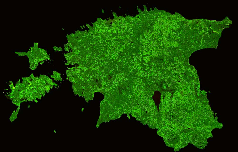
Remote sensing and GIS can be used to generate data that can help achieve sustainable management of natural resources. Maps created through a GIS interface provide a fillip to analysis and bring us a step closer to visualising the complex patterns and relationships that characterise real-world planning and policy problems.
Natural resources are depleting rapidly impacting development. The availability of time series Earth observation data assists the investigation of spatial patterns of different natural resources and the changes therein.
g-Governance can be described as a geospatial plugin to e-Governance, acting as an extended module with the additional functionality of geospatial technology. The article explains the genesis and geospatial constituents that are required for the implementation of g-Governance in India.
GIS And DISASTERS
Kerala has witnessed one of the most devastating floods in history. Many lives and livelihoods were lost in just a few days. To reduce future occurrences and the impact of such calamities, it is important that we focus on implementing and improving the measures that can offer greater resilience.
Flood is a complex outcome of an interface between geological, physiographical, hydrological, meteorological and anthropogenic dynamics. It mandates high computational techniques for the analysis of a large volume of hierarchical pictorial data. GIS technology, inseparably interleaved with remote sensing, helps to panoramically beam complex issues involving river floods and the feasibility of detecting and mitigating them.
Soil erosion is the removal of the top layer by natural agents. However, deforestation, overgrazing and infrastructural development accelerate soil erosion. As soil is a critical natural resource, the risk of its erosion must be addressed urgently. Use of modern technologies like remote sensing and GIS can help build an understanding towards risk mitigation.
Global changes due to the influence of extraterrestrial phenomena can be studied by using various satellite based information. An attempt is made in this article to understand the influence of such changes as a cumulative factor to predict some of the natural disasters which would make disaster management more effective.
IN CONVERSATION WITH
Kailasavadivoo Sivan, Chairman, Indian Space Research Organisation speaks with G’nY on the importance of geospatial technology in combating natural disasters like floods.
In brief
Humans are hardwired to orient themselves spatially. There was a time when accuracy in this endeavor won territories and filled coffers. Today, spatial information has ruptured the confines of a two dimensional output to capture domains of every conceivable discipline. Nothing is beyond mapping, whi
It is imperative to enhance India’s disaster management capabilities to help the government handle myriad disasters efficiently. The advancement of technologies, particularly in data acquisition, high end computation and processing have made significant progress in the recent past. It is important